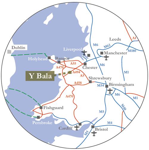
Travelling to the Bala area, North Wales
How to get to Bala

By Road:
- From the east: (national motorway network) M54 A5 A494
- From the north: M56 via Chester A483 A5 A494
- From South Wales: A470 to Dolgellau then A494
Time by Road to Bala:
- London: 4¼ hours (215 miles; 345 km)
- Hull: 3½ hours (175 miles; 280 km)
- Birmingham Airport: 2½ hours (110 miles; 190 km)
- Manchester Airport: 1½ hours (75 miles; 115 km)
- Liverpool Airport: 1½ hours (65 miles; 105 km)
- Chester: 1 hour (40 miles; 65 km)
- Wrexham: ¾ hour (30 miles; 50 km)
- Holyhead (Anglesey): 1¾ hour (72 miles; 120 km)
By Air:
The nearest airports are
- Liverpool (1½ hours by car)
- Manchester (1½ hours by car)
- Birmingham (2½ hours by car)
By Ferry:
- From Ireland: via Holyhead or Liverpool
- From northern Europe use the P&O North Sea Ferry from Zeebrugge or Rotterdam to Hull
By Train:
- The nearest railway stations are Wrexham, Chester and Barmouth
By Bus:
- Regular daily service: Chester-Wrexham-Bala-Dolgellau-Barmouth (T3 provided by GHA); bus timetable provided by Gwynedd Council
- National Express has a seasonal daily coach service London to Llangollen with connections to other routes, e.g. via Shrewsbury or Birmingham. There is a regular local bus service from Llangollen to Bala (see above).
Taxi:
- Biscuit Travel, Tel: 079 693 349 23 (8-seater available)
- Global Taxis (Bala), Tel: 078 503 702 32 (8/15-seater available)
More Information:
- Bus timetables provided by Gwynedd Council
- One-stop public transport information (bus, train, etc.): Traveline: 0871 200 22 33 Traveline-Cymru
- Route Planner from the AA
- UK Public Transport Planner
- Train Planner (all of the UK)
Travelling times by road are from the AA route planner, and are subject to traffic conditions, etc.